


La baume

raygautier
User
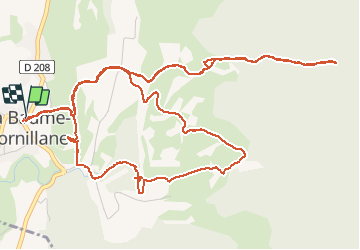

Length
9.8 km

Max alt
623 m

Uphill gradient
413 m
Km-Effort
15.3 km

Min alt
318 m

Downhill gradient
412 m
Boucle
Yes
Creation date :
2020-09-24 06:58:08.0
Updated on :
2020-09-24 11:41:32.074
2h58
Difficulty : Unknown

FREE GPS app for hiking
 SityTrail
IGN / Geographical institutes
SityTrail Plus
The world is yours!
About
Trail Walking of 9.8 km to be discovered at Auvergne-Rhône-Alpes, Drôme, La Baume-Cornillane. This trail is proposed by raygautier.
Positioning
Country:
France
Region :
Auvergne-Rhône-Alpes
Department/Province :
Drôme
Municipality :
La Baume-Cornillane
Location:
Unknown
Start:(Dec)
Start:(UTM)
661246 ; 4965342 (31T) N.
Comments